Birmingham City Council
Tree preservation zone
There is a problem
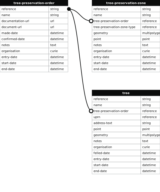
- 1000 entries with tree-preservation-order field must match the reference field in the tree preservation order dataset
THE BIRMINGHAM (CLARENCE ROAD - HILL HOOK ROAD, FOUR OAKS) TPO 1979
- reference
- 312
- name
- THE BIRMINGHAM (CLARENCE ROAD - HILL HOOK ROAD, FOUR OAKS) TPO 1979
- tree-preservation-order
- TPO 312
- tree-preservation-zone-type
- area
- geometry
- MULTIPOLYGON (((-1.850751 52.601671,-1.850835 52.601653,-1.850906 52.601481,-1.850850 52.601434,-1.850761 52.601365,-1.850683 52.601302,-1.850588 52.601229,-1.850485 52.601152,-1.850397 52.601089,-1.850092 52.600860,-1.849424 52.600353,-1.848663 52.600649,-1.848217 52.600293,-1.848132 52.600220,-1.847767 52.600348,-1.847738 52.600360,-1.847653 52.600390,-1.847649 52.600393,-1.847573 52.600414,-1.847525 52.600433,-1.847359 52.600504,-1.847308 52.600526,-1.847262 52.600548,-1.847424 52.600626,-1.847517 52.600679,-1.847535 52.600687,-1.847550 52.600698,-1.847572 52.600727,-1.847718 52.600941,-1.847393 52.601040,-1.847270 52.601074,-1.846995 52.601146,-1.846696 52.601216,-1.846518 52.601252,-1.846409 52.601272,-1.846209 52.601305,-1.846018 52.601331,-1.845810 52.601351,-1.845732 52.601356,-1.845634 52.601360,-1.845577 52.601366,-1.845562 52.601361,-1.845471 52.601396,-1.845407 52.601350,-1.845334 52.601246,-1.845220 52.601127,-1.845202 52.601106,-1.845123 52.601032,-1.845086 52.601002,-1.845013 52.600949,-1.844978 52.600921,-1.844967 52.600909,-1.844959 52.600897,-1.844829 52.600915,-1.844612 52.600950,-1.844477 52.600668,-1.844421 52.600451,-1.844258 52.600572,-1.844140 52.600652,-1.844113 52.600695,-1.843975 52.600811,-1.843706 52.600989,-1.844150 52.601747,-1.844672 52.602123,-1.844862 52.602249,-1.844968 52.602311,-1.845083 52.602371,-1.845283 52.602468,-1.845346 52.602494,-1.845432 52.602526,-1.845500 52.602547,-1.845562 52.602562,-1.845696 52.602584,-1.845950 52.602615,-1.846160 52.602621,-1.846292 52.602617,-1.846351 52.602613,-1.846393 52.602607,-1.846569 52.602575,-1.847192 52.602441,-1.847317 52.602409,-1.848089 52.602246,-1.848563 52.602139,-1.848989 52.602048,-1.849083 52.602026,-1.849453 52.601949,-1.849537 52.601930,-1.849582 52.601918,-1.849840 52.601863,-1.849995 52.601833,-1.850751 52.601671)))
- point
- POINT (-1.847303 52.601507)
- notes
- The shaded area represents those properties which fall within the outline of a Tree Preservation Order. To precisely identify trees protected by the Order, you can request a copy of the tree preservation order at the following link.
- entry-date
- 2026-10-15
- start-date
- end-date
How to fix this issue
Your data is missing a tree-preservation-order.
The tree preservation zone guidance explains how to fix the issue:
tree-preservation-order
The reference for the tree preservation order that covers this zone.
How to improve Birmingham City Council’s data
- Fix the errors indicated
- Use the check service to make sure the data meets the standard
- Publish the updated data on the endpoint URL